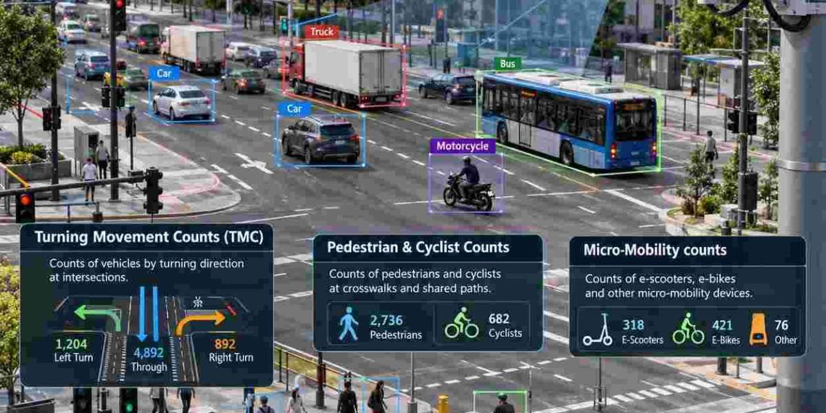
Traffic Surveys are the foundation of every sound transport decision in the UAE, from a new interchange on Sheikh Zayed Road to a pedestrian crossing outside a school. By measuring how vehicles, pedestrians, and cyclists actually behave, planners replace assumptions with evidence and invest where it matters most.
Across Dubai, Abu Dhabi, Sharjah, and the Northern Emirates, rapid population growth, large mixed-use developments, new metro and rail links, and a thriving tourism sector are reshaping how people move. Every one of those changes needs reliable numbers: how many vehicles use a road, which turns they make, and how many pedestrians, cyclists, and riders share the same space.
Why the UAE Needs Reliable Traffic Data Today
The UAE is one of the fastest growing transport markets in the region. Dubai's 2040 Urban Master Plan, the expansion of the Dubai Metro, the Etihad Rail network, and major destinations such as Expo City Dubai, Dubai Creek Harbour, and Yas Island in Abu Dhabi all place new demands on road networks that were originally designed for far lower volumes.
Authorities including the Roads and Transport Authority (RTA) in Dubai and the Department of Municipalities and Transport in Abu Dhabi expect developers and consultants to support planning applications with credible, current traffic evidence. Assumptions copied from older studies are no longer a safe basis for design, and a poorly evidenced traffic impact assessment can delay an approval.
What Are Traffic Surveys and Why Do They Matter
A structured survey programme measures how a road network is used. Surveyors, sensors, or cameras record vehicles, pedestrians, and cyclists at specific locations and times, and the raw observations are then converted into figures engineers can use: hourly flows, peak periods, vehicle mix, turning proportions, speeds, and queue behaviour.
These figures feed directly into a wide range of planning and design tasks. A survey is also the baseline against which any improvement is judged, because only a before and after comparison can show whether a new layout genuinely improved safety or journey times. Typical uses include:
- Traffic impact assessments: supporting planning applications for new developments
- Junction and signal design: sizing lanes and setting phase timings from measured demand
- Road safety and school zone reviews: identifying where people and vehicles conflict
- Parking and access planning: testing entrance capacity and drop off areas
- Public transport and active travel planning: linking stations, stops, and walking routes
- Pavement and maintenance planning: estimating the loading that heavy vehicles place on a road
Automated Traffic Counts (ATC): Continuous Volume and Speed Data
Automated Traffic Counts (ATC) use pneumatic tubes, radar units, inductive loops, or video sensors to record every vehicle passing a fixed point, usually for seven days in a row or longer. Because the equipment runs around the clock, it captures the full daily rhythm of a road, including morning and evening peaks, midday lulls, weekend patterns, and the night traffic that a short manual count would miss.
In the UAE the weekly pattern matters. With the working week for most employees now running from Monday to Friday and the weekend falling on Saturday and Sunday, a count must span a complete week to show the true difference between weekday and weekend demand. Seasonal effects such as Ramadan, school terms, summer travel, and major events also shift volumes, so good practice is to record the survey period and compare it with typical conditions.
Typical outputs include hourly and daily volumes, peak hour factors, average daily traffic, directional splits, and spot speed distributions. These support capacity checks, noise and air quality assessments, and the geometric design of roads.
Classified Vehicle Counts: Understanding the Vehicle Mix
Not every vehicle affects a road in the same way. Classified Vehicle Counts separate traffic into categories such as motorcycles, cars, light goods vehicles, buses, and heavy goods vehicles, often with further subdivision by axle count. A road carrying a high share of trucks, such as the corridors serving Jebel Ali Port and the industrial areas of Sharjah, needs very different geometry and pavement strength from a residential street with the same total volume.
Classification also supports freight route planning, truck restriction decisions, emissions modelling, and pavement design, where heavy vehicles cause far more cumulative damage than cars. Passenger car unit factors derived from the classified data allow mixed traffic to be converted into a single equivalent figure for capacity analysis.
Turning Movement Counts (TMC): Mapping Every Junction Movement
While a tube count describes a road, Turning Movement Counts (TMC) describe a junction. Each approach is observed to record how many vehicles turn left, go straight, or turn right, normally in fifteen-minute intervals across the morning, midday, and evening peaks. The result is a complete movement matrix that shows exactly where demand is concentrated and where conflicts occur.
Engineers use this matrix to calibrate junction models in tools such as Synchro, PTV Vissim, and Aimsun, to set signal phasing and cycle lengths, to size turn lanes, and to judge whether a roundabout, a signalised junction, or a grade separated interchange is the right solution. Junctions around dense areas such as Business Bay, Downtown Dubai, and the Abu Dhabi Corniche are typical places where accurate turning data decides the layout.
Pedestrian & Cyclist Counts: Measuring Active Travel
Walking and cycling are growing parts of the UAE mobility mix, supported by projects such as the Al Qudra cycling track, the Dubai Marina and Jumeirah promenades, and new shared paths along waterfronts. Pedestrian & Cyclist Counts record how many people pass or cross at a given point, where they cross, and at what times, and they can separate pedestrians, cyclists, and users of mobility aids.
These counts justify new crossings, wider footpaths, shade and shelter, school zone protection, and better connections to metro and tram stations. They also give a safety perspective, because the points where crowds of pedestrians meet turning vehicles are exactly where collisions are most likely to happen.
Micro Mobility Counts: Electric Scooters and Shared Bikes
Electric scooters, shared bicycles, and similar personal devices have become a visible part of urban travel in the UAE, and regulators such as the RTA have introduced designated zones, permits, and rider rules to manage them. Micro Mobility Counts measure how many of these devices use a corridor, which paths or carriageways they occupy, and how they interact with pedestrians and motor vehicles.
Without this data it is difficult to decide whether a corridor needs a protected lane, a wider shared path, or speed limits for devices. A count that treats scooters as either cyclists or pedestrians hides the real picture, which is why a separate category is now standard in a carefully planned survey.
ATC & TMC Camera Technology: Accurate Data Without Roadside Risk
A modern ATC & TMC Camera records traffic on video, and analytics software then counts and classifies vehicles, pedestrians, cyclists, and scooters from the footage. Compared with roadside surveyors, this approach removes fatigue and human error, avoids placing staff beside fast traffic, and works through the night with infrared capable units.
Because the footage is stored, every count can be checked later. If a figure looks unusual, the engineer can replay the exact interval and verify it, which gives clients and approving authorities a level of audit confidence that a tally sheet cannot match. Cameras can also capture movements at complex multi lane junctions where manual observers struggle to keep up.
Responsible camera surveys also respect privacy. Footage is used only for counting, stored securely, removed according to agreed retention rules, and handled in line with the UAE Personal Data Protection Law. Installation points are chosen to give a clear view of every movement while avoiding private property.
Emerging Trends: AI Video Analytics and Smart City Integration
The UAE's smart city ambitions are changing what traffic data can do. Artificial intelligence now classifies road users from video with high accuracy, detects near misses, and measures queue lengths and speeds without any extra hardware. Permanent monitoring points can feed dashboards that show how a corridor performs from week to week, rather than relying on a single snapshot.
Even so, a permanent sensor network does not replace a purpose designed survey. Temporary counts remain the most economical way to study a specific junction, a new development, or a proposed scheme, and the best programmes use short term surveys to calibrate and complement long term monitoring.
Traffic Surveys UAE: Choosing the Right Method for Each Project
Choosing a method starts with the question the study must answer. The Traffic Surveys UAE market covers everything from a single junction count for a villa development to a corridor wide programme for a metropolitan master plan, and the right combination of techniques differs for each:
- Corridor capacity and growth: continuous tube or radar counts across a full week
- Junction redesign and signal timing: peak period movement counts recorded on video
- Freight routes and pavement design: vehicle classification by axle and body type
- School, mall, and station access: pedestrian, cyclist, and scooter count with crossing locations
- Parking and drop off studies: entry and exit counts with occupancy checks
- Before and after evaluation: identical methods and locations repeated after construction
Combining methods is often the most efficient route. A single camera installation can serve junction movement counts and pedestrian counts at the same time, while a tube count on the main approach adds speed data that video alone may not provide.
Traffic Surveys Dubai: Local Conditions That Shape Survey Planning
A Traffic Surveys Dubai assignment must account for conditions unique to the emirate. Peak traffic on Sheikh Zayed Road, Al Khail Road, and the Emirates Road corridor builds early and lasts long, and events such as GITEX, the Dubai Airshow, and the Dubai Shopping Festival can distort normal patterns for days.
Surveys are therefore scheduled outside school holidays, the fasting month, and major events unless those conditions are exactly what the study needs to capture. Summer heat above forty degrees, dust, and strong sun glare also affect equipment placement and camera angles, so enclosures, shading, and ventilation must be planned from the start. For projects reviewed by the RTA, it is good practice to agree survey locations, dates, and methods with the reviewer in advance to avoid rework.
Sectors and Projects That Depend on Traffic Evidence
Real estate developers use survey data to support planning submissions and to size access roads, car parks, and entrances for residential towers, business parks, and communities. Retail malls, hotels, and entertainment destinations rely on it to manage peak day visitors, valet areas, and pedestrian links to metro stations.
Schools and universities need it to design safe drop off zones. Ports, logistics parks, and industrial areas depend on it to manage truck movements. Government entities and infrastructure contractors use it to prioritise road upgrades, justify public spending, and verify that completed schemes deliver the benefits promised at the design stage.
How Top Precisions Delivers Traffic Surveys Across the UAE
Top Precisions provides professional traffic surveys for developers, consultants, contractors, and government entities across Dubai, Abu Dhabi, Sharjah, and the wider UAE. Each assignment begins with a clear brief, a survey plan that identifies locations, methods, dates, and equipment, and an agreed reporting format, so that results can be used directly in the client's traffic impact assessment or design package.
The team combines trained field engineers with modern video and sensor equipment, and every dataset passes through a validation stage before delivery. Organisations comparing professional traffic data collection services in the UAE can discuss survey scope, equipment options, and turnaround times directly with the Top Precisions team, and can review the full-service range on the company website.
Data Quality, Validation, and Reporting Standards
Accurate data is only useful if it can be trusted. A credible survey provider calibrates its equipment before deployment, compares automated counts against a manual verification sample, documents any gaps caused by obstructions or weather, and records the exact dates, times, and locations in a method statement that the reviewing authority can inspect.
Deliverables should include clean data tables in spreadsheet format, peak hour summaries, volume diagrams, site photographs, and a short methodology note. Data prepared in standard formats can be imported straight into modelling and signal design software, which saves the design team time and avoids transcription mistakes.
Experience matters just as much as equipment. Engineers who have worked across the UAE understand how local driving behaviour, lane discipline at roundabouts, and mixed pedestrian flows around malls and metro stations affect what should be counted and how, and they place cameras and sensors accordingly.
Manual Counts Versus Camera Counts: Choosing the Right Approach
Manual counts still have a place. For a short study at a simple junction, a trained observer with a tally device can be quick to arrange and cost effective. The limits appear as soon as the study becomes longer, busier, or more complex. Observers tire after an hour or two, struggle with four or five lane approaches, and cannot be asked to repeat an interval that has already passed.
Camera based surveys cover longer periods, handle heavier flows, and give a permanent record. They also make it easier to run several count types at once, so one installation can deliver vehicle classes, turning movements, pedestrian crossings, and scooter use together. The practical choice is often a hybrid, with cameras doing the continuous work and a small manual sample used to validate the automated counts.
From Raw Counts to Design Decisions: How Survey Data Is Used
Raw counts become useful once they are processed into planning inputs. Peak hour volumes set the design hour for a junction, growth factors project today's demand to the opening year and the design year, and trip generation checks confirm whether a new development will add the volumes assumed in the transport statement.
The same data supports level of service calculations, queue length estimates, signal timing plans, and microsimulation models. In each case the quality of the output depends entirely on the quality of the input, which is why careful survey design and validation deserve as much attention as the modelling that follows.
Safety, Permissions, and Site Preparation for Field Surveys
Field work on or beside live roads carries real risk, so a responsible provider plans for safety before any equipment is installed. That includes site risk assessments, high visibility clothing, safe mounting positions away from the carriageway, and clear procedures for any work close to traffic.
Permissions also matter. Cameras mounted on street furniture, buildings, or temporary poles may need approval from the road owner, the municipality, or the property manager, and projects on private estates or inside free zones may have their own rules. Building these approvals into the programme at the start prevents delays once the survey window is fixed.
The Business Case: Why Accurate Counts Save Time and Money
A survey is a small share of any project budget, yet it influences decisions worth many times its cost. An under counted junction leads to congestion soon after opening, while an over counted one leads to unnecessary lanes, land take, and construction spend. Accurate data also supports faster approvals, because reviewers can verify the evidence instead of requesting repeated clarifications.
For developers, reliable counts protect the project schedule. For government entities, they protect public funds and provide a defensible record when the performance of a new road layout is later questioned.
The Survey Process: From Brief to Final Report
A properly run assignment follows a predictable sequence, which keeps the client informed and the programme on time:
- Briefing and scoping: confirm objectives, study area, and approving authority requirements
- Site reconnaissance: check sight lines, mounting points, power, and safety
- Survey plan: agree locations, methods, time windows, and equipment
- Data collection: deploy counters and cameras and monitor them during the survey
- Processing and validation: extract counts, run quality checks, and verify against samples
- Reporting: deliver tables, diagrams, and a methodology note ready for submission
Conclusion
Traffic Surveys give UAE planners the evidence behind every sound road decision. Automated Traffic Counts (ATC) and Classified Vehicle Counts show volume and vehicle mix. Turning Movement Counts (TMC) and Pedestrian & Cyclist Counts reveal junction demand. Micro Mobility Counts and an ATC & TMC Camera capture modern travel with accuracy. For Traffic Surveys UAE and Traffic Surveys Dubai, Top Precisions is a trusted partner.
FAQs
- What are Traffic Surveys and when does a UAE project need one?
Traffic Surveys measure how vehicles, pedestrians, and cyclists use a road or junction. Any project that adds traffic or changes a layout, such as a new development, a school, a mall, or a junction upgrade, normally needs reliable Traffic Surveys to support planning and design approvals.
- How long should Automated Traffic Counts (ATC) run?
A standard programme records Automated Traffic Counts (ATC) for seven days in a row so the data shows both weekday and weekend patterns. Longer periods are used where seasonal effects or special events must be captured.
- What is the difference between Classified Vehicle Counts and Turning Movement Counts (TMC)?
Classified Vehicle Counts sort traffic into vehicle types such as cars, buses, and trucks, while Turning Movement Counts (TMC) record the left, straight, and right movements at a junction. Many projects need both, because one describes the traffic mix and the other describes junction behaviour.
- Do pedestrians, cyclists, and scooters need special counting methods?
Yes. Pedestrian & Cyclist Counts and Micro Mobility Counts use dedicated categories and crossing locations, because these road users move differently from motor vehicles and carry different safety risks.
- Is camera-based counting accurate enough for Dubai projects?
Yes. An ATC & TMC Camera keeps a stored record that can be replayed and checked against a manual sample, which gives approving authorities strong confidence in the results of a Traffic Surveys Dubai assignment.